Crisis Point Maps and Infographics
New research shows massive threats to the Amazon and Congo tropical forests from global oil and gas expansion. An area six times the size of the UK threatened and tens of millions of Indigenous and local community members at risk.
Threat Assessment of Oil and Gas Expansion: A Risk to Intact and Undesignated Lands
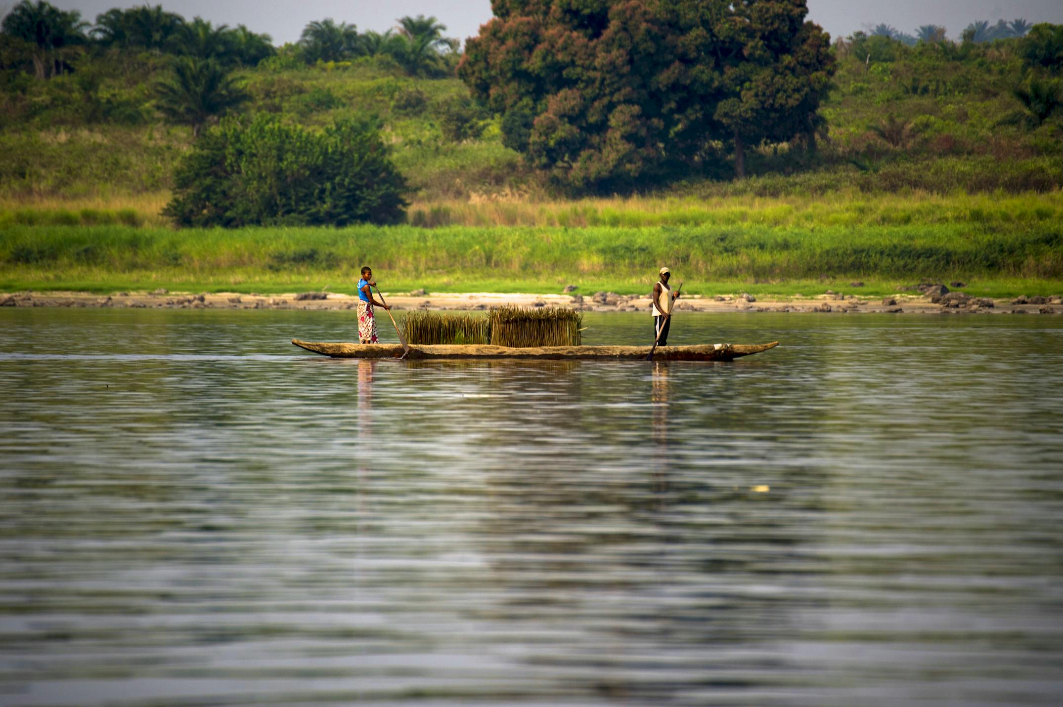
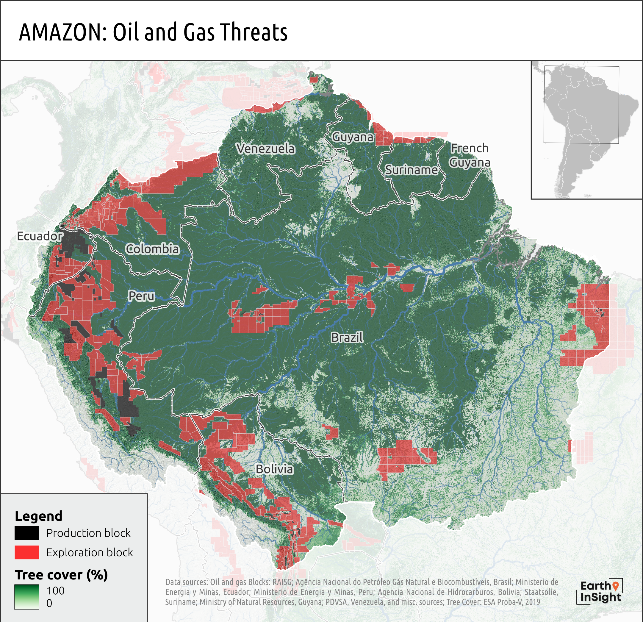
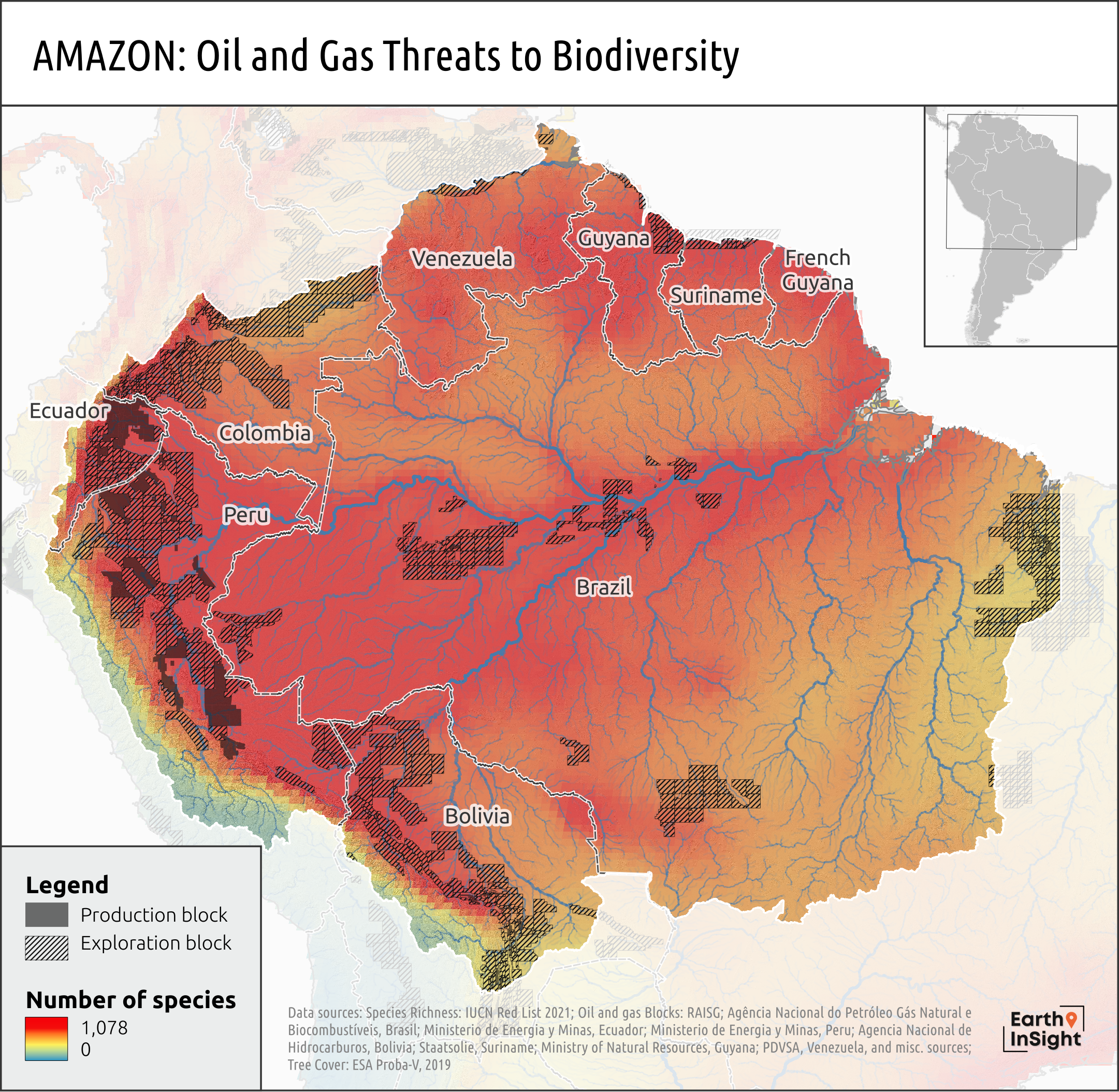
Oil and gas expansion is one of a range of threats that is driving the Amazon to the brink. Agribusiness (cattle, palm oil, soy, etc.) have been and continue to be the biggest drivers of deforestation and high degradation. Oil and gas development brings large infrastructure, roads, etc. and has been a gateway to deforestation. This region contains the richest biodiversity on the planet. An estimated 65 million hectares of undisturbed tropical forest (an area nearly twice the size of Poland) now overlap with existing or planned oil and gas blocks in the Amazon Basin and over 12 million people living in more than 10,000 villages, towns, etc., or more than 20% of populated places in Amazonia are now in oil and gas blocks.
An Existential Threat to Indigenous People and an Ongoing Toxic Legacy
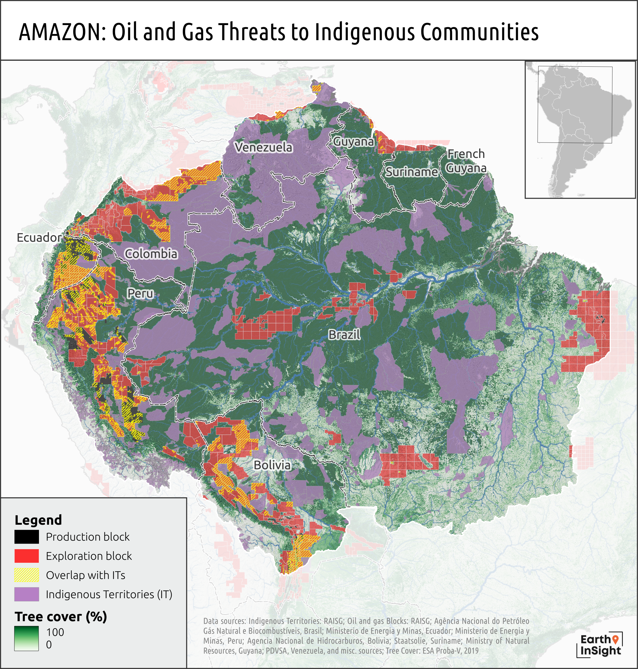
Oil extraction and deforestation lead to violations of Indigenous Peoples’ rights and are threats to their survival and cultural stability. Indigenous federations and a vast majority of Indigneous communities are opposed to the expansion of oil and other industrial activities in their territories. Yet the oil industry continues to advance into their territories and frontier rainforests. Over 500 distinct Indigenous nationalities call the Amazon Basin home and more than 25 million hectares of Indigenous Territories and customary lands are now in oil and gas blocks and more than 20% of populated places (over 1,800 villages, towns, etc.) in Indigenous Territories are under a current production or designated exploration oil and gas block
Oil “Development” in the Western Amazon: A Cautionary Tale
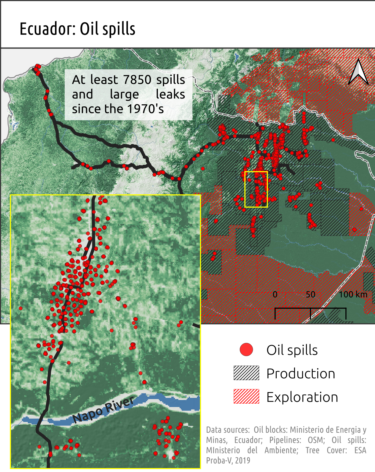
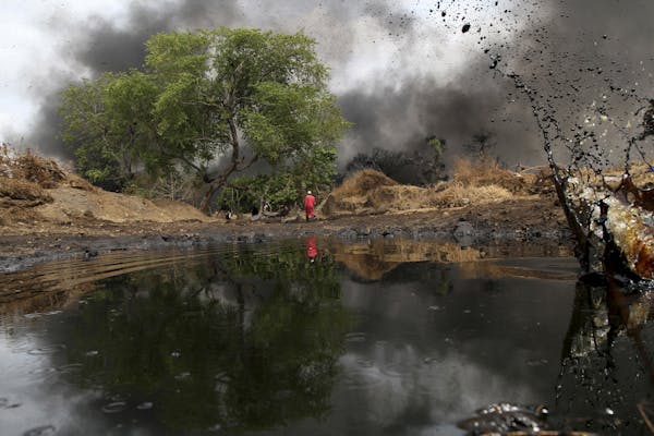
The history of oil-related contamination in the Western Amazon spans decades. Fossil fuel extraction has brought with it toxic waste and crude oil spilled from extensive and poorly-maintained pipelines. Oil development has also been associated with exposure to heavy metals and contaminants and cancer rates as high as four times that of reference populations. Major pipeline ruptures in 2022 and 2020 have heavily impacted the water resources of the Indigenous and local communities who live within the impact zone of the oil and gas industry. Since 1972 at least 7,850 spill sites have been inventoried by the Ministry of Environment of Ecuador. At the same time, the aging Norperuano pipeline in the Peruvian Amazon continues to spill regularly; it is estimated more than 450 oil spills have occurred in the Peruvian Amazon since 2000. Indigenous resistance has been a steady force to oil expansion and other forms of extractivism with a steady arc of victories keeping oil, mining, and other extractive interests out of their territories and customary lands. As Indigenous Federations and a range of civil society organizations have been calling attention to, millions of hectares of rainforest in the Western Amazon are now under imminent threat due to oil and gas expansion. With 90% of Amazonian oil exports coming out of Ecuador, this region is a critical hotspot and a microcosm of the dangers of a path that most often leads to debt, pollution, corruption, Indigenous rights violations, and civil unrest. In order to pay off debt and meet economic demand by exporting oil to refineries in California – where half of all Amazon crude oil ends up – the Ecuadorian government is hoping to double oil production; putting millions of hectares of primarily roadless, intact rainforest at risk.
Threat Assessment of Oil and Gas Expansion: A Risk to Biodiversity
The Amazon and specifically, its headwaters is the world’s most biodiverse region in the world. The Amazon region 40% of the world’s remaining rainforest, at least 25% of its known terrestrial biodiversity, and more fish species than in any other river system. The greatest species richness in the world is found along the transition of the Amazon lowland basin to the Andes mountains headwaters in Colombia, Ecuador, Peru and Bolivia. Due to its unique geology this region also has the most intensive oil production and exploration.
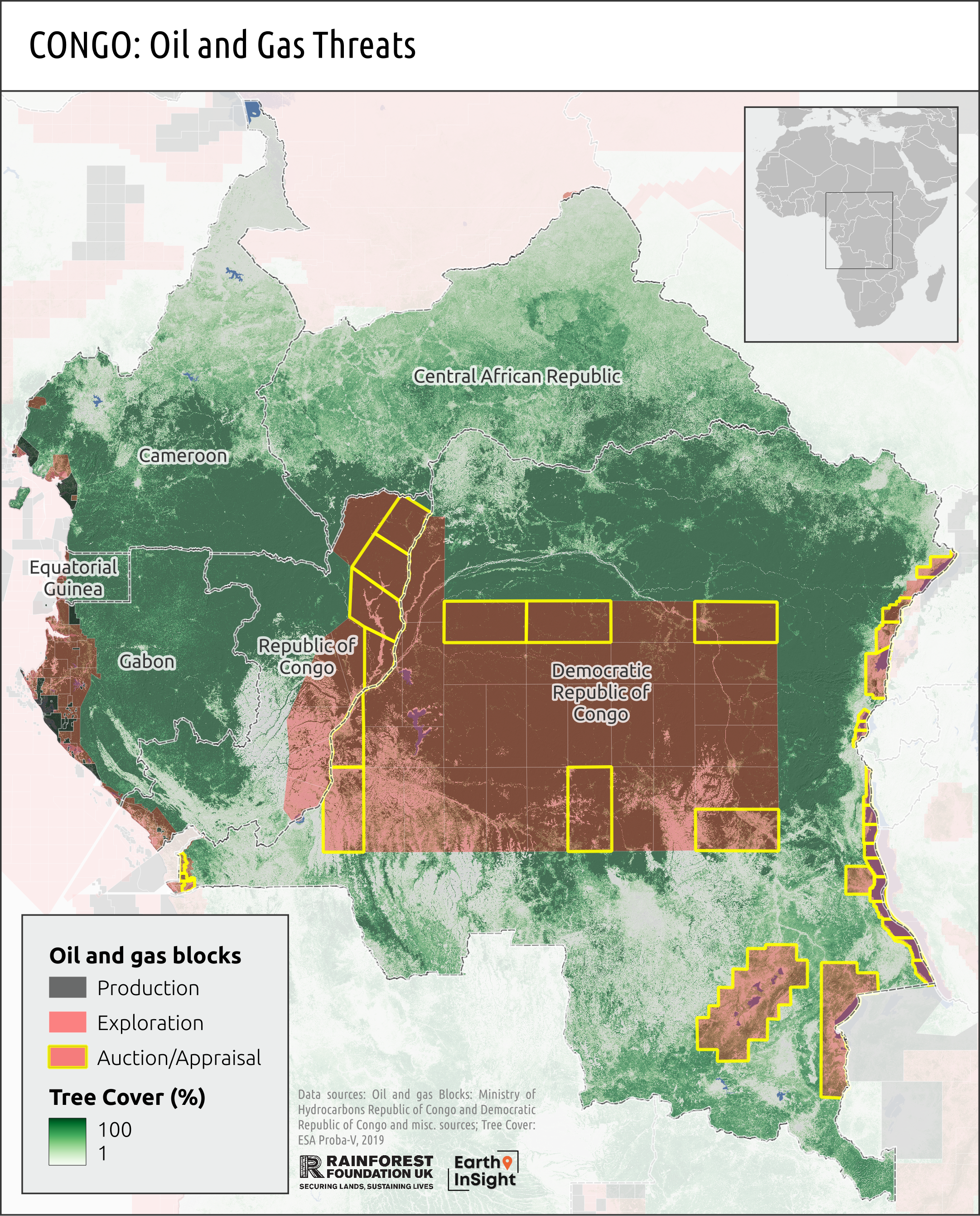
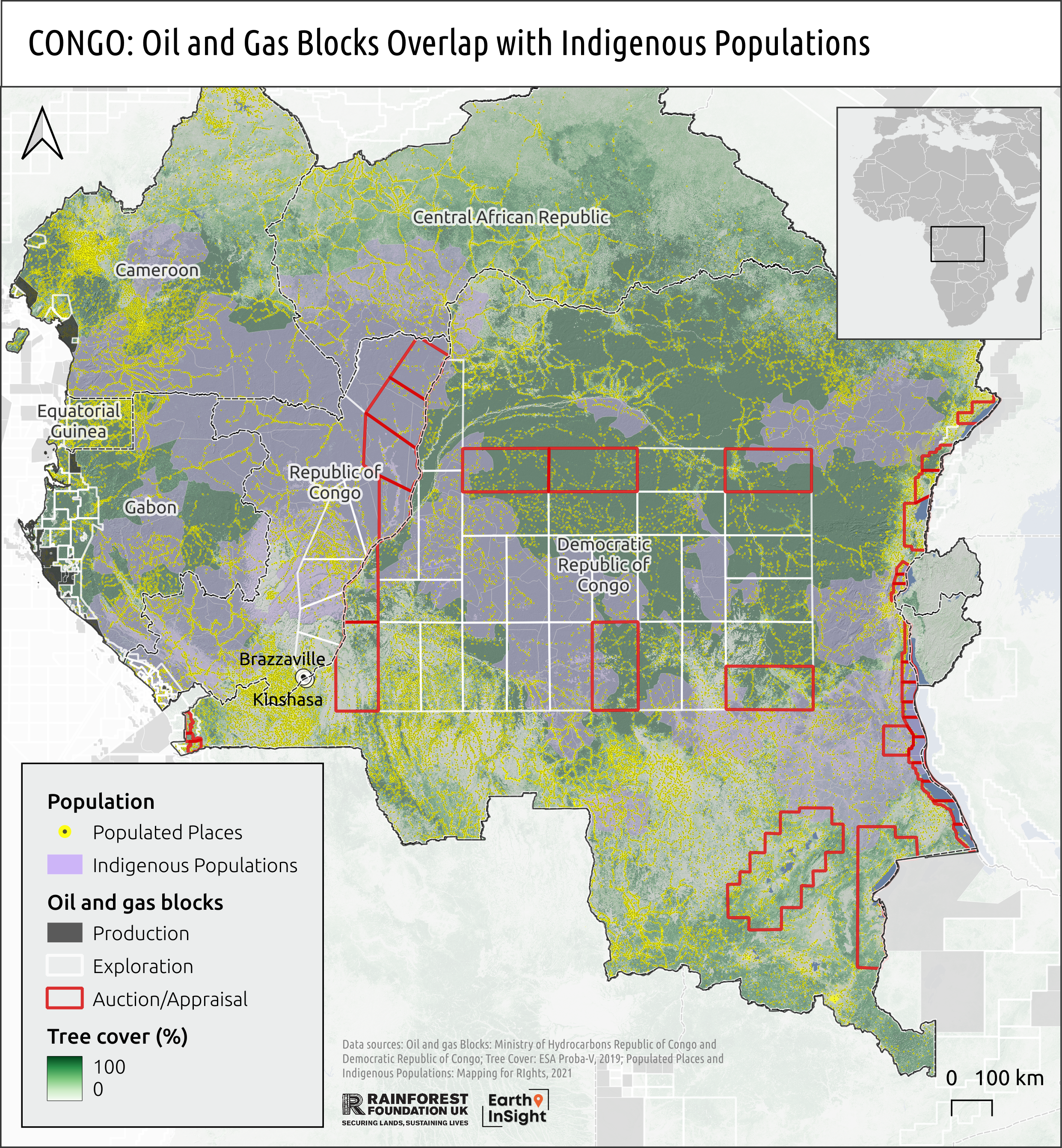
The Congo Basin contains 90% of Africa's undisturbed tropical forests that overlap with oil and gas blocks making the region the epicenter of oil and gas expansion threats to undisturbed tropical forests on the continent, and likely the world.
Oil and gas expansion in the Congo Basin threatens to further fragment intact lands and exacerbate forest and wetland degradation and deforestation in the region. Over 180 million hectares of undisturbed tropical forests remain in the region and over 35% of these forests, or 64 million hectares (an area nearly twice the size of Germany), now overlap with over 150 production or designated exploration oil and gas blocks.
In addition to the immediate threats to forests and the climate, the indirect and cumulative impacts in terms of the required roads, drilling equipment, pipelines, rigs, processing plants and use of local water sources are still higher. This infrastructure would in turn open up previously intact forest areas to a ‘cascade’ of deforestation as loggers, settlers and poachers move in.
It is estimated that in the Congo Basin countries, there are over 81,000 populated places – as identified in the map above. These places are comprised of cities, towns, and villages and our analysis shows that 20% or over 16,000 populated places – representing nearly 36 million people – overlap with oil and gas blocks in the region.
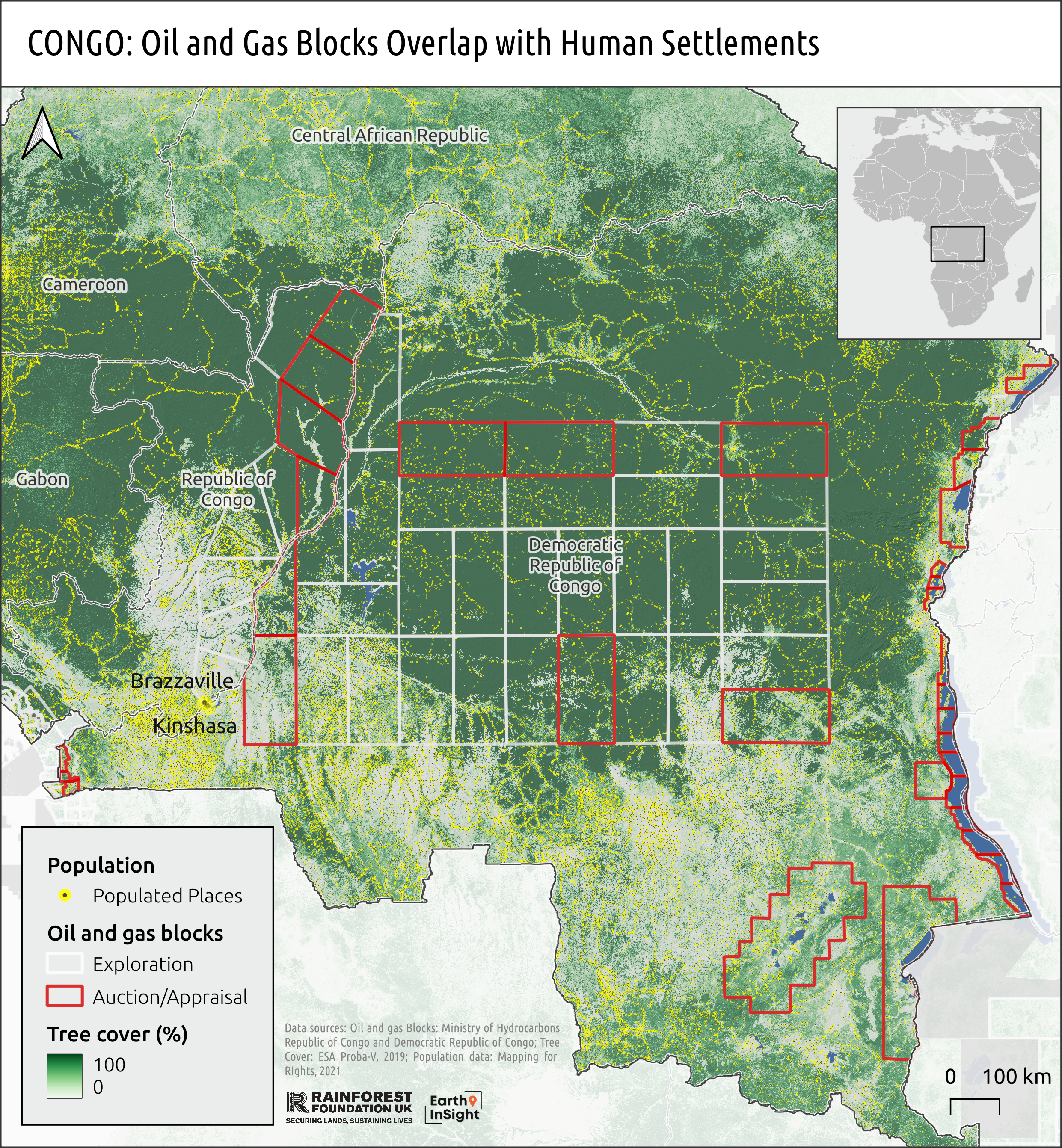
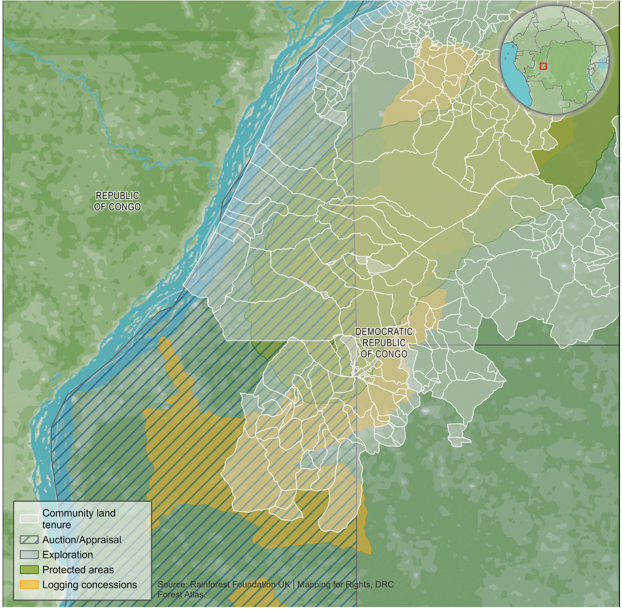
Many communities in the region are characterized by a high degree of forest-dependency with livelihood and cultural activities extending well beyond population centers. As represented in the map below, participatory mapping with local communities supported by Rainforest Foundation UK and its local partner organizations indicates the entire forest area is likely to be subject to long-standing collective tenure claims. However, these systems mostly still lack legal recognition, leaving many communities living in industrial concessions and more vulnerable to having their lands further dispossessed by oil and gas expansion.
The oil and gas blocks also extensively overlap administrative areas that are inhabited by Indigenous Peoples. Both the Republic of Congo (2011) and the DRC (in process) have Indigenous Peoples laws that are supposed to safeguard the rights of Indigenous Peoples. The latter even requires the free, prior and informed consent (FPIC) of Indigenous Peoples in relation to development projects on their lands.
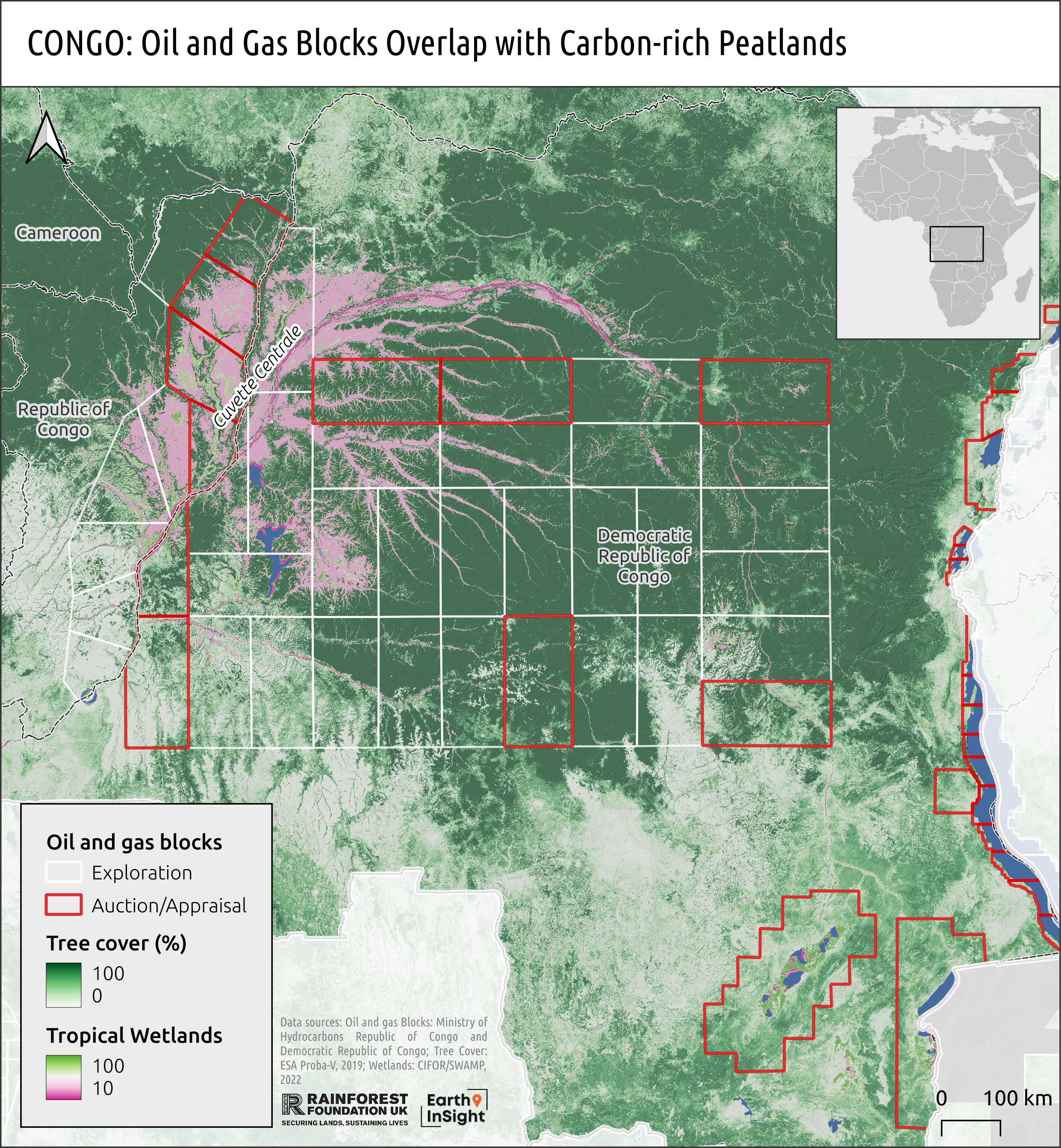
Three oil blocks (4, 4B and 22) overlap with the Cuvette Centrale peatlands, a globally vital carbon sink storing an estimated 29 billion tonnes –- or three years’ worth of global fossil fuel emissions. The peat in these three oil blocks alone store 1.67 billion tonnes of carbon – equivalent to the carbon emitted by burning 14.2 billion barrels of oil, according to the CongoPeat initiative. This is in addition to several oil blocks that have already been allocated over these peatlands in the neighboring Republic of Congo, including to oil majors Total and ENI.
Related Content
-
 Map/Infographic
Crisis Point Maps and Infographics
-
 Map Story
Mapping the East African Crude Oil Pipeline (EACOP)
- Insight
A Global Crisis Point: Oil and Gas Expansion in Critical Ecosystems
-
 Project
Mapping the East African Crude Oil Pipeline (EACOP)
-
 Event
EventNew York Climate Week: No time to spare
-
 Map Story
Land allocated to oil, gas exploration in Africa set to quadruple, threatening forests
-
 Press Release
Tropical forests have reached a crisis point