Technical Insight: Oil exploration threats to Conkouati-Douli National Park in Republic of Congo
Just two months after signing a $50 million forest protection deal with donors at COP 28, the Republic of Congo awarded an oil and gas exploration permit to a little-known Chinese company in Conkouati-Douli National Park, the country’s most biodiverse protected area. New maps and analysis show the permit poses substantial risk to tropical forests, endangered species, and the local communities that have lived in the zone for centuries.
Earth Insight’s newly-released research shows that, together with the Conkouati block, numerous other unawarded oil and gas blocks overlap over half the park.
Introduction
Just four months after hosting the Three Basins Summit in Brazzaville, the Republic of Congo’s Council of Ministers awarded SNPC (National Petroleum Company of the Congo; owner, 15%) and China Oil Natural Gas Overseas Holding Limited (CONGO; operator, 85%) an exploration permit for the Conkouati block on February 8th, 2024 (JO n°2024-09). The previously unexplored and unlicensed Conkouati block overlaps with the Conkouati-Douli National Park and buffer zone, the country’s most biodiverse national park (WCS 2016). Conkouati-Douli National Park protects over 5,000 km of coastal, marine, and forest ecosystems where the Congo’s tropical rainforest meets the Atlantic ocean (Parcs de Noé 2022a). The park, which is also a recognized Ramsar site, is home to key endangered wildlife species, including the Western lowland gorilla, the leatherback turtle, and the forest elephant (Parcs de Noé 2022a), as well as approximately 7,000 people in 28 villages from multiple ethnic groups whose livelihoods depend on the forest (One Earth, n.d.). Together with the Mayumba National Park in Gabon, the park forms the Mayumba-Conkouati Transfrontier Landscape (WCS 2016). In October 2024, CONGO announced that it was investing $150 million over the next three years to bring machinery and personnel to begin intensive oil exploration (Sikiti da Silva 2025).
Conkouati-Douli National Park was initially established in 1999 by Presidential decree and was co-managed by Wildlife Conservation Society with the government. This co-management arrangement ended in 2018 (One Earth n.d.) In April 2021 Noé, a French conservation NGO, signed a partnership agreement and assumed the daily operational management of the National Park (Parcs de Noé 2022b). In October 2023, Conkouati-Douli National Park was extended by an additional 2,900 km2 of offshore area (WCS 2022).
The 1999 decree that founded the park states that exploration and exploitation permits can only be granted within areas designated as ‘eco-development zones,’ but that extractive activities are not allowed within the 5km buffer zone on the South and East sides of Conkouati-Douli National Park (Décret n° 99-136). Currently, the only recognition of this potential violation in the Council of Ministers notes are instructions for the “Ministries of Hydrocarbons and Forest Economy to ensure the planned activity is carried out intelligently and compatible with the preservation requirements of this protected area” (Ministry of Communication and Media, 2024, translation).
Main Findings
The Geography of Conkouati-Douli National Park
Conkouati-Douli National Park sits on the coast of the Republic of Congo, along the border with Gabon. The National Park aims to conserve over 8,000 km2 (3,900 km2 of land and 4,100 km2 of marine area - including the 2023 marine extension), and the park buffer zone covers an additional 800 km2. Conkouati-Douli National Park represents an important coastal and tropical forest landscape and is the most biodiverse protected area in the Republic of Congo. Our spatial analysis finds that 86% of the land area of the park – or 3,400 km2 – is tropical moist forest, an area that increases to 3,900 km2 when expanded to include the buffer zone. The park additionally conserves an important hydrologic ecosystem including over 130 km2 of wetlands, rivers, lakes and streams. There has been evidence of forest loss in the park since 2000, however most forest loss is concentrated in the buffer zone and eco-development zones of the park close to buffer zones and roads.
There are an estimated 58 populated places – primarily villages and small settlements – within the national park. Noé estimates that the park is home to approximately 7,000 people (Parcs de Noé n.d.) from various ethnic or Indigenous origins (One Earth n.d.).
Currently, over 65% of Conkouati-Douli National Park overlaps with oil and gas blocks (either available or with exploration permits), not including the MPA extension or buffer zone. Of the 3370 km2 of oil and gas blocks that overlap with the National Park, approximately 990 km2 are permitted for exploration and 2,380 km2 remain unlicensed blocks. The largest overlap with an exploration block is with the Conkouati block.
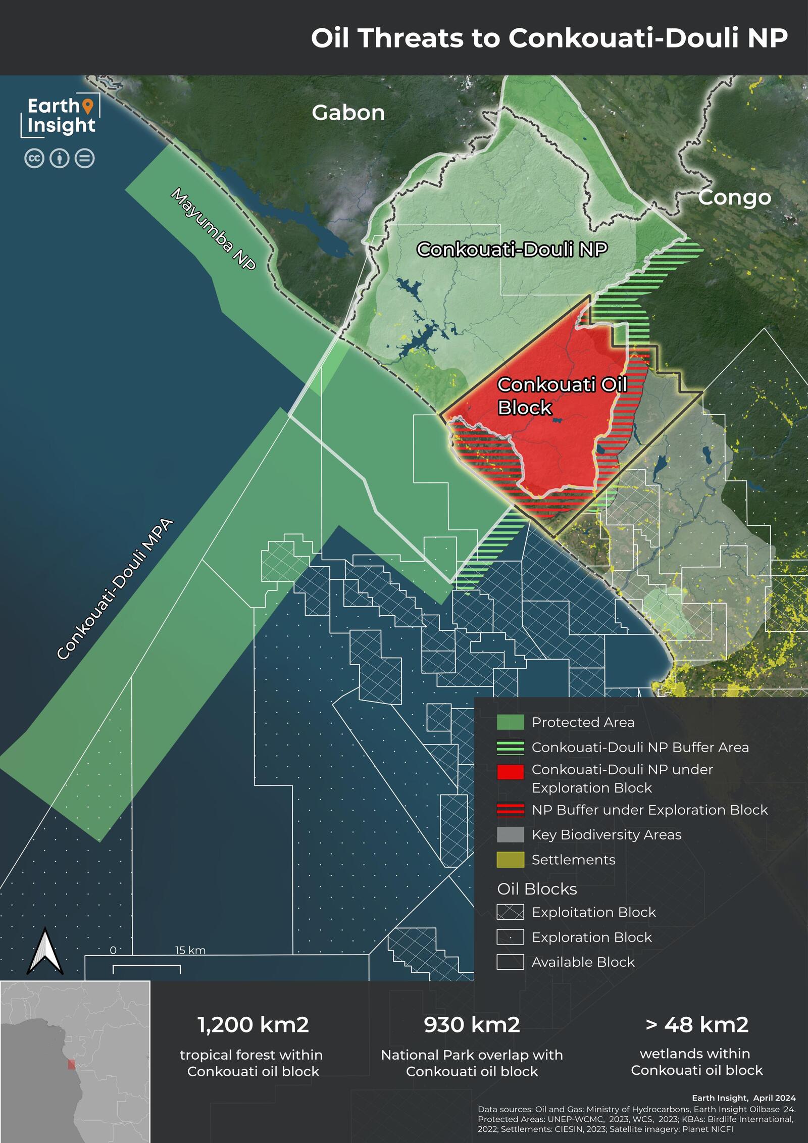
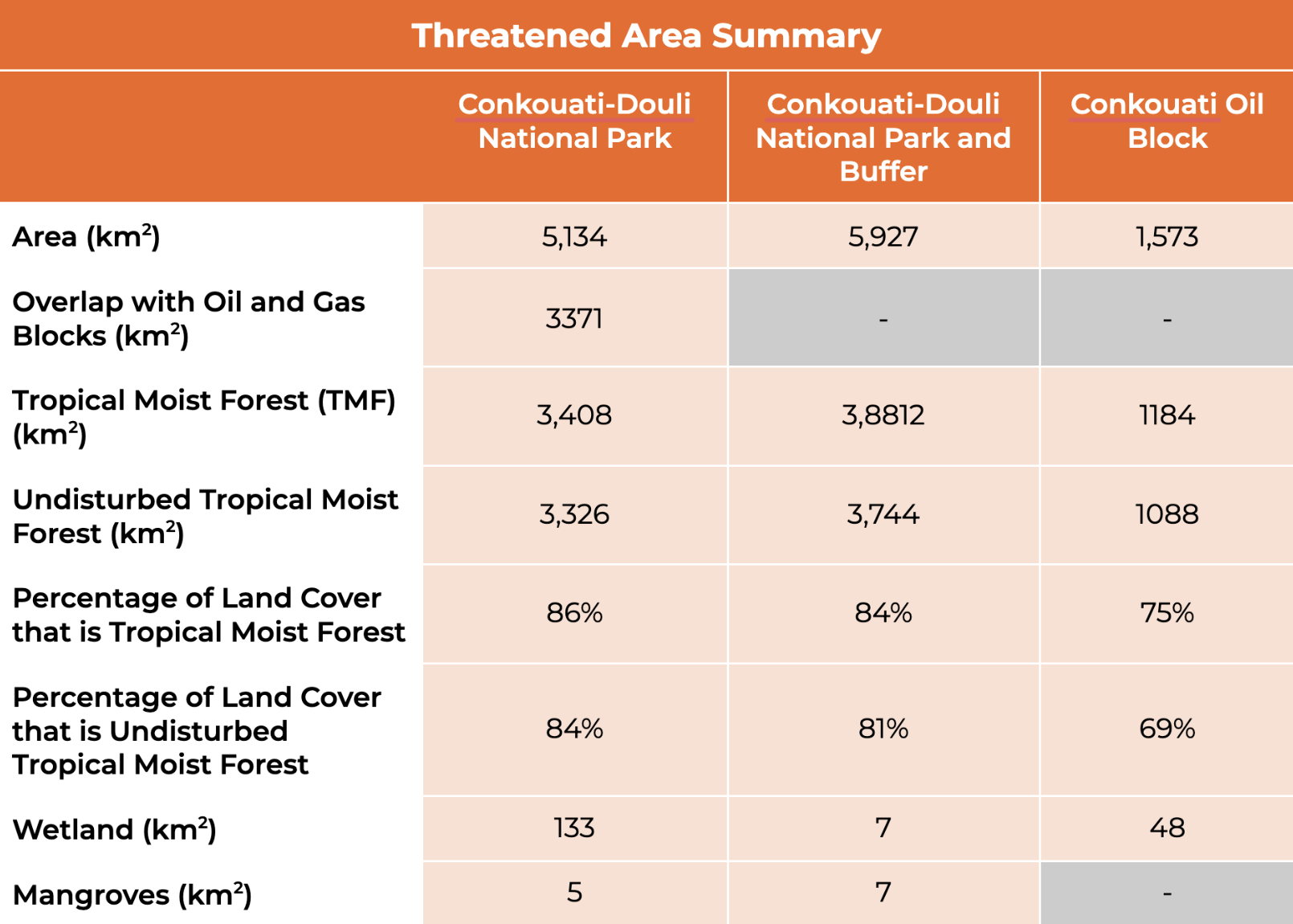
Table 1: Protected Area Data
Oil Exploration in Conkouati
The threat of oil and gas exploration, along with other extractive activities, has been present in the park since Conkouati-Douli was first created. The park’s founding decree in 1999 declared that extractive permits could not be granted in the park, except in eco-development zones (Decree n° 99-136). Eco-development zones cover approximately 1700 km2 (33%) across Conkouati-Douli National Park and the majority of settlements are within these eco-development zones. The decision to permit the Conkouati oil block for exploration in February 2024 will have significant consequences for the conservation and landscape integrity of the block and the park as a whole.
The Conkouati oil block is nearly 1,600 km2 large and extends from the coastline into the tropical forest, overlapping with Conkouati-Douli National park, the buffer zone, and the Conkouati-Douli Ramsar site. Tropical forest covers 75%, or 1,200 km2, of the newly-permitted block. Over 91% of the forest within the Conkouati oil block is currently undisturbed tropical forest. New oil exploration poses an additional threat to coastal mangroves.
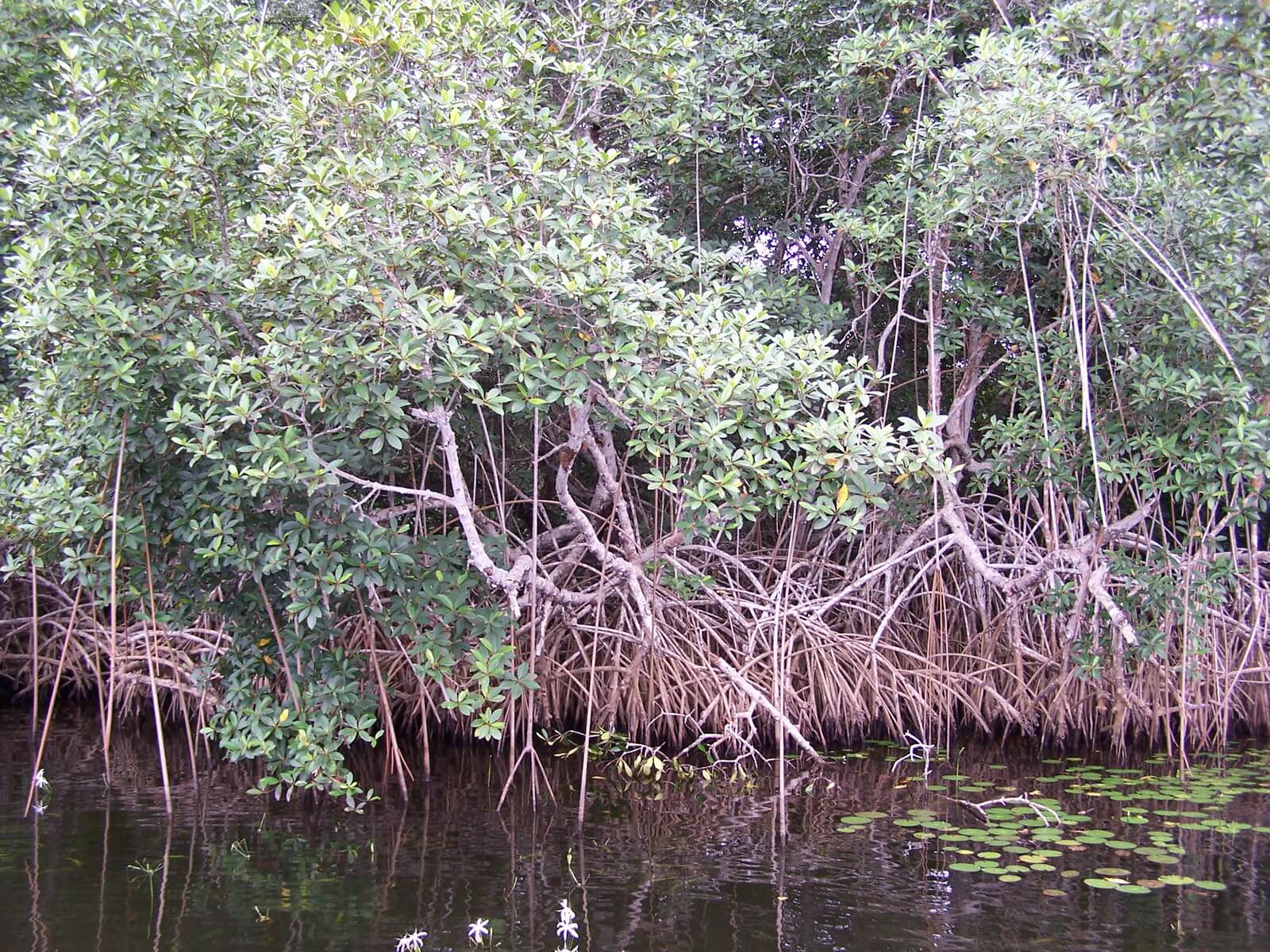
Mangrove forest in Conkouati-Douli National Park. Image credit: John Flynn, USAID via Flickr (CC BY-NC 2.0).
The majority of the Conkouati oil block overlaps with the Conkouati-Douli National Park or the park’s buffer zone. There is 930 km2 of overlap with the national park, and an additional 440 km2 of overlap with the buffer zone. Within the overlap with Conkouati-Douli National Park, the permitted Conkouati oil block overlaps with less than 700 km2 area designated as an eco-development zone. Oil exploration, along with other extractive and economic activities are only legally permitted within the eco-development zone or outside of the national park and buffer zone boundary. If oil exploration in the Conkouati oil block complies with these regulations, approximately 900 km2 is available for oil exploration – 700 km2 across two non-contiguous eco-development zones and 200 km2 outside of the park and buffer zone.

Threatening Biodiversity
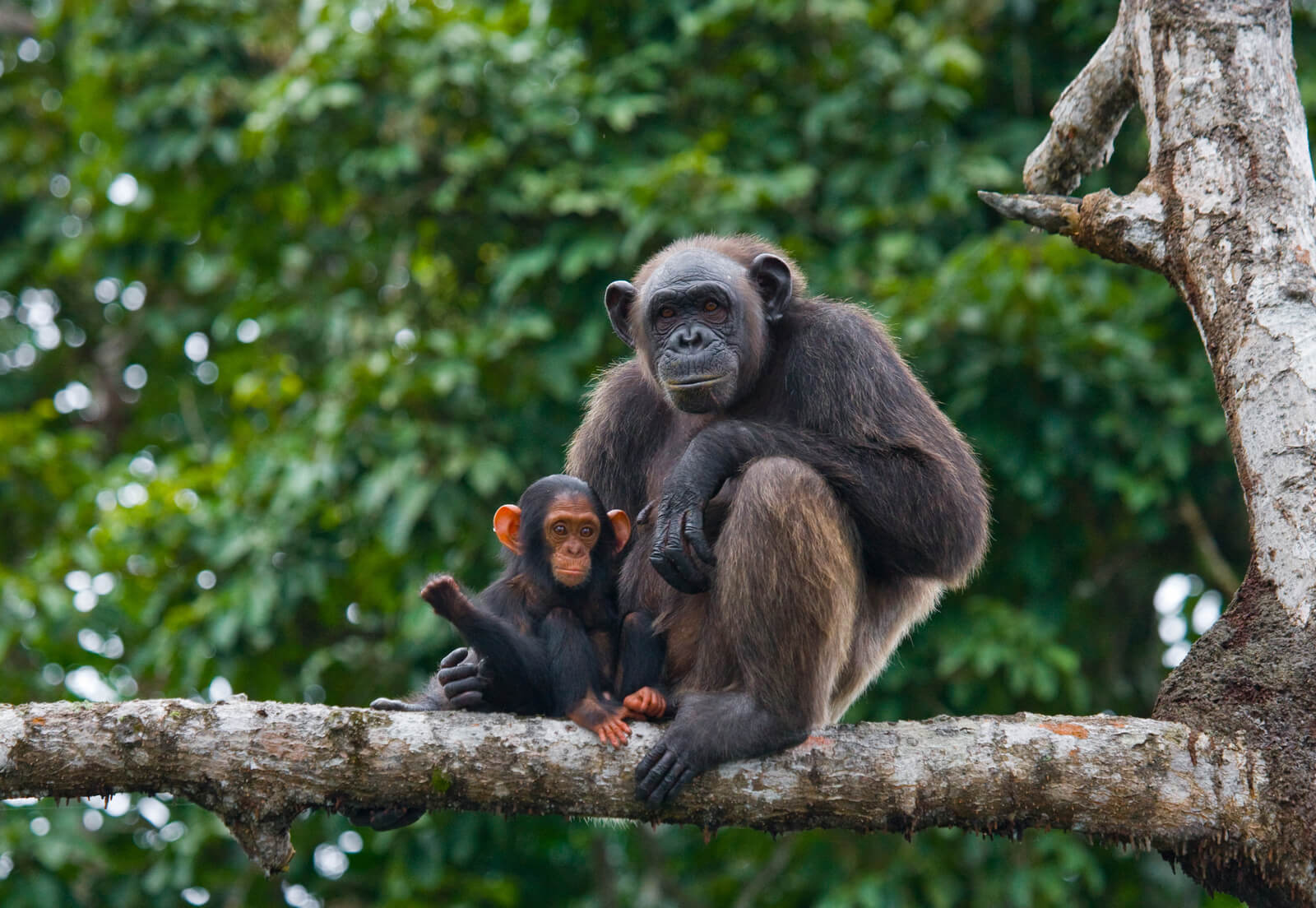
A female chimpanzee with a baby on mangrove trees. Republic of the Congo. Conkouati-Douli Reserve. Image credit: Discover Corps via Flickr (CC BY-ND 2.0).
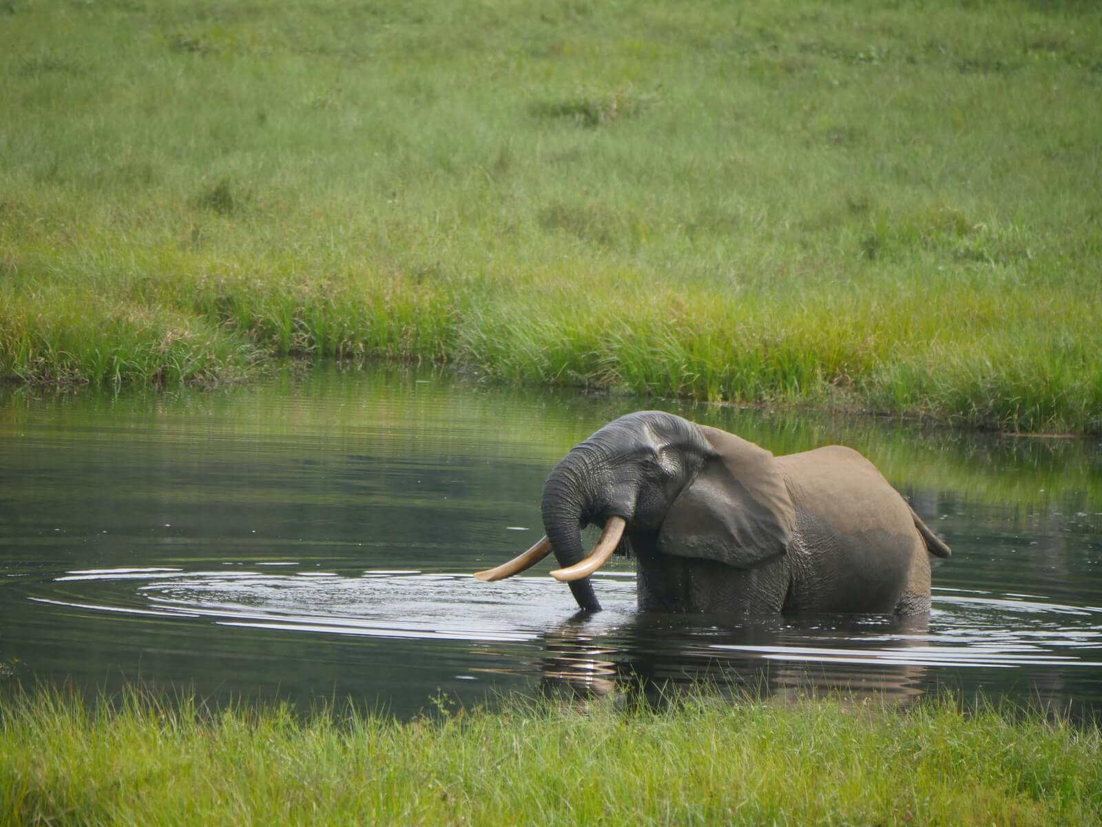
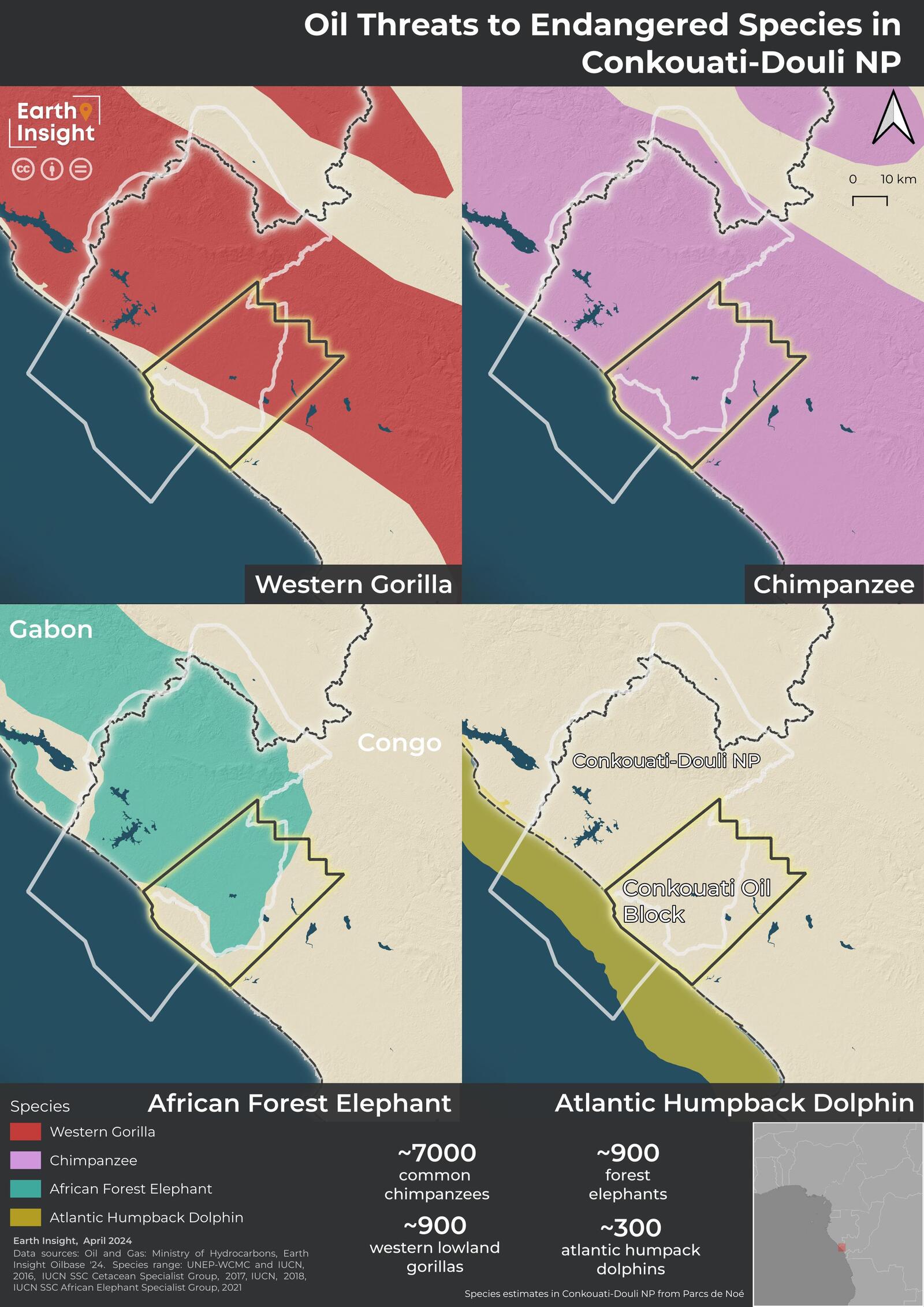
The Conkouati oil block also poses a direct threat to Key Biodiversity Areas. Only a quarter of the Conkouati oil block is not designated as a Key Biodiversity Area. Conkouati-Douli National Park is Congo’s most biodiverse national park and provides an important habitat for critically endangered species including Western Gorillas, African Forest Elephants, and Atlantic Humpback Dolphins, as well as endangered Chimpanzees in addition to many other key and endangered species.
The Conkouati oil block overlaps with the IUCN habitat ranges for Western Gorillas, African Forest Elephants and Chimpanzees among other species mean that any exploration and future production would have a significant impact on already threatened population numbers (Parcs de Noé 2022a).
Recommendations
The Conkouati oil block poses a direct threat to Congo’s tropical forests, biodiversity, and the livelihoods that depend on this landscape. Given the threats to nature and people, we make the following recommendations:
- Immediately cancel the Conkouati oil block and ban extractive exploration and extraction (fossil fuels, mining, and logging) in Conkouati-Douli National Park and Buffer zone, including in eco-development zones.
- Remove currently unlicensed oil and gas blocks that overlap with Conkouati-Douli National Park from Congo’s mining domain.
- Ensure that community rights to access, use, and manage resources within the park are protected and that management plans with Noé are developed in partnership with local communities. Increasing protection against extractives must not be used to limit community rights.
- Commitment from Congolese government to diversify the economy and phase out reliance on the fossil fuel sector (currently 50% of GDP and 80% of exports and government revenue).
- Explore large-scale debt relief, with strong environmental and social safeguards, that could unlock hundreds of billions of dollars to protect forests, strengthen community rights, and support long-term climate and economic resilience.
Methodology
All analyses and mapping were conducted using open-source tools such as QGIS, python and R.
Forest Cover
The forest cover area within Conkouati-Douli National Park and under Conkouati oil block was calculated by intersecting the JRC Tropical Moist Forest (TMF) cover product (Vancutsem et al., 2021) with the park layer, using Zonal Histogram, and then summarizing the number of pixels within the park. The same steps were repeated with the buffer zone polygon and oil block polygon.
Forest Loss
The forest loss area within Conkouati-Douli National Park and under Conkouati oil block was calculated by intersecting the 2023 Hansen Global Forest Change product (Hansen et al, 2013) with the park layer, using Zonal Histogram, and then summarizing the number of pixels of forest loss per year within the park. The same steps were repeated with the buffer zone polygon and oil block polygon.
Wetlands
We calculated the extent of wetlands within Conkouati-Douli National Park and under Conkouati oil block using the CIFOR Tropical and Subtropical Wetlands Distribution dataset (Gumbricht et al, 2017). The wetlands product was intersected with the park layer, using Zonal Histogram, we excluded category 10 (open water) and summarized the pixels for the remaining wetland categories within the park. The same steps were repeated with the buffer zone polygon and oil block polygon.
Mangroves
To assess the threats to mangroves we used the Global Biophysical Typology of Mangroves data layer (Worthington et al., 2020). We intersected this layer with the oil and gas block layer to calculate the overlap of mangroves with oil and gas.
Protected Area data
The protected areas data used in this analysis are from the World Database of Protected Areas (UNEP-WCMC and IUCN, 2023). The database identifies a range of classes which reflects their primary management objectives (Dudley 2008).
- Ia - Strict nature reserve
- Ib - Wilderness area
- II - National park
- III - National monument or feature
- IV - Habitat and species management area
- V - Protected landscape or seascape.
- VI - Protected area with sustainable use of natural resources
- Not applicable/no classification
Onshore Protected Areas
Protected areas with IUCN categories I - IV were selected based on IUCN recommendations that no oil and gas extraction should occur in these protected areas. Protected areas that did not have a IUCN category but were designated ‘National Parks’ were recategorized as IUCN category II to account for the gaps in reported attribute data for certain countries. Duplicate and overlapping protected area features were removed before running the area-based analysis. Marine Protected Areas were removed using `Marine != 2` to preserve protected areas in coastal and tidal landscapes as well as terrestrial protected areas.
Marine Protected Areas
The Marine Extension to Conkouati-Douli National Park is not currently part of the IUCN-WCMC World Database on Protected Areas. To reflect this update, we digitized the MPA.
Eco-Development Zones
Spatial data for eco-development zones was digitized from a PAPACO Management Effectiveness Training Tool report. The eco-development zone layer was then intersected with the Conkouati oil block layer. The eco-development zones and overlap areas should only be used as estimates and not as definitive boundaries.
Geospatial Data Sources
Forest Cover: C. Vancutsem, F. Achard, J.-F. Pekel, G. Vieilledent, S. Carboni, D. Simonetti, J. Gallego, L.E.O.C. Aragão, R. Nasi. Long-term (1990-2019) monitoring of forest cover changes in the humid tropics. Science Advances 2021
Wetlands: Gumbricht, T.; Román-Cuesta, R.M.; Verchot, L.V.; Herold, M.; Wittmann, F; Householder, E.; Herold, N.; Murdiyarso, D., 2017, "Tropical and Subtropical Wetlands Distribution", https://doi.org/10.17528/CIFOR/DATA.00058, Center for International Forestry Research (CIFOR), V7, UNF:6:Bc9aFtBpam27aFOCMgW71Q== [fileUNF]
Forest Loss: Hansen, M. C., P. V. Potapov, R. Moore, M. Hancher, S. A. Turubanova, A. Tyukavina, D. Thau, S. V. Stehman, S. J. Goetz, T. R. Loveland, A. Kommareddy, A. Egorov, L. Chini, C. O. Justice, and J. R. G. Townshend. 2013. High-Resolution Global Maps of 21st-Century Forest Cover Change. Science 342 (15 November): 850-53. Data available on-line from: https://glad.earthengine.app/view/global-forest-change.
Mangroves: Worthington, T.A., zu Ermgassen, P.S.E., Friess, D.A., Krauss, K.W., Lovelock, C.E., Thorley, J., Tingey, R., Woodroffe, C.D., Bunting, P., Cormier, N., Lagomasino, D., Lucas, R., Murray, N.J., Sutherland, W.J., Spalding, M., 2020. A global biophysical typology of mangroves and its relevance for ecosystem structure and deforestation. Sci. Rep. 10, 14652. https://doi.org/10.1038/s41598-020-71194-5
Protected Areas: UNEP-WCMC and IUCN (2024), Protected Planet: The World Database on Protected Areas (WDPA) and World Database on Other Effective Area-based Conservation Measures (WD-OECM) [Online], January 2024, Cambridge, UK: UNEP-WCMC and IUCN. Available at: www.protectedplanet.net.
Eco-Development Zones: Management Effectiveness Tracking Tool (METT): Conkouati-Douli National Park. July 2011. PAPACO. Available at https://papaco.org/wp-content/uploads/2015/09/METT-Parc-national-Conkouati-Douli.pdf
Oil and Gas Blocks: Republic of Congo, Ministry of Hydrocarbons.
Settlements: Center for International Earth Science Information Network (CIESIN), Columbia University and Novel-T. 2023. GRID3 Republic of the Congo Settlement Extents, Version 02. Palisades, NY: Geo-Referenced Infrastructure and Demographic Data for Development (GRID3). https://doi.org/10.7916/nw1r-3b27. Accessed 7th May, 2024
Populated Places: The populated places database was derived from the Geographic Names Server maintained by the US National Geospatial-Intelligence Agency.
African Forest Elephant Geographic Range: Gobush, K.S., Edwards, C.T.T, Maisels, F., Wittemyer, G., Balfour, D. & Taylor, R.D. 2021. Loxodonta cyclotis (errata version published in 2021). The IUCN Red List of Threatened Species 2021: e.T181007989A204404464. https://dx.doi.org/10.2305/IUCN.UK.2021-1.RLTS.T181007989A204404464.en. Accessed on 10 April 2024
Chimpanzee Geographic Range: Humle, T., Maisels, F., Oates, J.F., Plumptre, A. & Williamson, E.A. 2016. Pan troglodytes (errata version published in 2018). The IUCN Red List of Threatened Species 2016: e.T15933A129038584. https://dx.doi.org/10.2305/IUCN.UK.2016-2.RLTS.T15933A17964454.en. Accessed on 10 April 2024
Western Gorilla Geographic Range: Maisels, F., Bergl, R.A. & Williamson, E.A. 2018. Gorilla gorilla (amended version of 2016 assessment). The IUCN Red List of Threatened Species 2018: e.T9404A136250858. https://dx.doi.org/10.2305/IUCN.UK.2018-2.RLTS.T9404A136250858.en. Accessed on 10 April 2024
Atlantic Humpback Dolphin Geographic Range: Collins, T., Braulik, G.T. & Perrin, W. 2017. Sousa teuszii (errata version published in 2018). The IUCN Red List of Threatened Species 2017: e.T20425A123792572. https://dx.doi.org/10.2305/IUCN.UK.2017-3.RLTS.T20425A50372734.en. Accessed on 10 April 2024.
Geoboundaries: Runfola, D. et al. (2020) geoBoundaries: A global database of political administrative boundaries. PLoS ONE 15(4): e0231866. https://doi.org/10.1371/journal.pone.0231866
Works Cited
Creation of Conkouati-Douli National Park, Décret n° 99-136 (14 August, 1999)
Dudley, N. (ed.) (2008). Guidelines for Applying Protected Area Management Categories. IUCN WCPA. Best Practice Protected Area Guidelines Series No 21, CGland Switzerland: IUCN. ISBN: 978-2-8317-1636-7
Ministry of Communication and Media, Republic of Congo. (2024, January 18). Council of Ministers Meeting Minutes 18/01/2024. https://www.sgg.cg/ccm/compte-rendu-cmd-2024-01-18.pdf
One Earth. (n.d.). Protecting and restoring Conkouati-Douli in the Congo Basin. Retrieved March 31, 2024, from https://www.oneearth.org/projects/protecting-and-restoring-conkouati-douli/
Parcs de Noé. (2022a). Conkouati-Douli National Park, Congo. https://parcsdenoe.org/wp-content/uploads/2022/11/pl-congo-uk.pdf
Parcs de Noé. (2022b). Rapport D’Activité 2022. https://indd.adobe.com/view/392425b3-2308-4647-937e-12452bb0021d
Parcs de Noé. (n.d.). PARCS CONGO https://parcsdenoe.org/en/parcs-congo/
Secretariat General of the Government of Republic of Congo. Journaux Officiel n°2024-09 du 29/02/2024
Sikiti da Silva, I. (2024, February 4). Too little, too late - Congolese blame activists as Chinese company gears to rip up national park for oil. AfricaInFact. https://africainfact.com/too-little-too-late-congolese-blame-activists-as-chinese-company-gears-to-rip-up-national-park-for-oil/
WCS (2022)The Republic of the Congo Announces the Creation of the Country’s First Marine Protected Areas. https://newsroom.wcs.org/News-Releases/articleType/ArticleView/articleId/17981/The-Republic-of-the-Congo-Announces-the-Creation-of-the-Countrys-First-Marine-Protected-Areas.aspx
WCS. (2016, April 11). Conkouati-Douli National Park. https://wcscongoblog.org/portfolio_page/conkouati-douli-national-park/
This work is licensed under the Creative Commons license CC BY-ND 4.0 DEED Attribution-NoDerivs 4.0 International. Please find a copy of this license here. If you have any queries, please address them to info@earth-insight.org.
Suggested Citation: Earth Insight (2024). Technical Insight: Oil infrastructure threats to Conkouati-Douli National Park in Republic of Congo. CC BY-ND 4.0.
DISCLAIMER: The content contained in this document is provided for information purposes only. Earth Insight aims to provide the public with tools and analyses that elevate understanding, best practices, and ambitions for protection of nature, climate, and people. This document has been prepared using publicly available information, with sources cited as of the date they were last accessed before publication. Earth Insight has undertaken all reasonable due diligence to ensure the accuracy of this information, but changes in circumstances after publication may impact its accuracy. Earth Insight is not responsible or liable for the content of any third-party material that may be contained in this document. If you believe any information in this document is not accurately represented, please contact info@earth-insight.org with information supporting your position and a request for a correction. Earth Insight will review your request and make any necessary corrections.